
🕊️ A Movement and Place Framework for Nature
We often plan for nature like its movement needs to be catered for and an inconvenience. It isn't. It has movement and place needs much like humans.

Good day my good friend.
This week has been a good week. I have spent much of it catching up with friends new and old at Active County Cambridgeshire and the Transport Practitioners Meeting. It is always energising to laugh and joke, and to engage in serious discussions in between, and it always recharges my batteries. For those of you I said hello to, it was honestly a pleasure. For those who I did not get a chance to, I am sorry to have missed you. We will talk again soon.
Oh, and we do not mention the disappointment of Wednesday evening. Ever. Ok?
This year, Mobility Camp is coming to Sheffield on 30th September, and it promises to be another amazing day of discussion, debate, and taking action. Anyone with an interest in transport should be there, and so should you. You can get tickets here.
A couple of months ago, in between attending an International Transport Forum conference in Leipzig and going to see my sister and my nephews in Weinheim, I stayed over in Frankfurt. I got the chance to explore not only the extensive public transport system (which is amazing) and see the work they have done to encourage more cycling (also amazing). But I also got to see something you rarely see within cities in Europe.
The Frankfurter Stadwaldt literally translates as the Frankfurt City Forest. It is an extensive forested area to the south of the city of around fifty-eight square kilometres, of which just under forty are officially within the city limits. My work on Forest City has got me interested in how we best integrate extensive habitats such as forests within the build form of the city, and how it interacts with the transport networks that are so fundamental to city life. So in the morning I headed out of my city centre hotel, boarded tram line 17 just outside the front door, and headed south.
As the tram skirts through the suburbs and alongside the railway line, the trees appear ever more frequently, and before you know it you are in a forest of, well, trees. The tram flies past the trunks, with the occasional dirt track in view, before it pulls into the tram stop at Oberschweinstiege. On this morning, a group of young school children also alighted at the stop with me, with people whom I assumed were their teachers, heading to what my sister later informed me was a ‘Forest School’ where they had practical lessons in nature and conservation.
What really struck me when walking around the forest for most of the morning was the contrast between the different types of transport infrastructure and their effects on the experience of being in the forest. For much of the walk, the birds sang loudly and I could hear scratching in the undergrowth. Even the occasional stag beetle crossed my path. This is to be expected, as for most of the trails it is walking and cycling only, so apart from the occasional cyclist and groups of dog walkers, I spent much of the time on my own.
When I was close to the tram tracks, the bird song was as loud as any other place in the forest. While the tram line itself cuts a thin slither through the trees, and the occasional tram speeding past did disturb the peace, the sounds of nature continued unabated. This was also the case a short time later when planes from Frankfurt Airport – the sixth busiest airport in Europe and the main operational hub of Germany’s national carrier Lufthansa – started to fly overhead. While the engines of departures to all corners of Europe and the World screamed overhead, the birdsong fell silent. Once the metallic birds had left, the ones that were living reasserted their dominance.
Note: You need the sound on for this video
This was not the case, however, for the roads that crossed the forest.
I walked up to the Isenberg Schneise, a relatively minor radial route cutting through the forest that, while not as busy as the Autobahns close by, had a steady stream of vehicles of all types. As I approached on the gravel path, the low hum of the traffic started to build and the sounds of birdsongs and insects diminished. To the point where, as I stood by the roadside, the only animal that I managed to hear was a dog in the field used as parking for fans attending the nearby football stadium.
Note: You need the sound on for these videos
At the time, it left me with a thought about how, if we were to design a city with nature at its heart, we would practically have to rip up all roads, and have no vehicular access within the city limits. From my observations, nature was more easily able to adapt to the presence of trams, trains, and even planes, compared to that of cars. Yet, as I began to read of the work that Frankfurt am Main does on nature conservation, and the wider literature on road ecology, I realised something more profound, and something that we often forget when we think of the relationship between transport and nature.
Nature is more flexible, and more stubborn, than we give it credit for.
Much of the dominant narrative around the relationship between transport and nature is focussed around one thing. Transport infrastructure being wildlife corridors, and how our movement corridors – rail or road – act as a severance between habitats. We build green bridges over motorways, thread mammal tunnels beneath them, fence amphibians towards culverts, and talk about stitching severed habitats back together.
The assumption is that our job is to help nature move through the infrastructure we have built, to reconnect what our roads and railways have cut apart. That work is real and worth doing. But I have come to think it rests on a mistake, and the mistake is to treat movement as the whole of what nature needs from our land. In many respects, it repeats the same mistakes that we made when thinking of our streets for many decades – seeing them as corridors of movement only.
Biodiversity is not mainly a problem of movement. Species need corridors to move along, but they also need places to be, patches and islands of habitat where they feed, breed, shelter and simply stay. A landscape that offers only movement is, in its own way, as impoverished as one that offers only isolation. As transport planners we spent decades learning that a street is not only a link for through traffic but a place in its own right. The same distinction, movement and place, is what nature needs us to apply to the land our infrastructure occupies.
The corridor has become the respectable face of nature in scheme design, and it deserves some of its good reputation. Over the past two decades, green bridges, wildlife crossings and amphibian fencing have moved from the fringe to the mainstream, and the principle behind them is sound. Infrastructure severs habitats, isolated populations wither, and reconnecting them helps. None of that is wrong. Animals need to move to new hunting grounds, water sources, and of course migrate.
The trouble is what the corridor habit quietly assumes. It casts the road as a barrier and nothing else, a wound in the landscape whose only remedy is a bridge across it. In their landmark review Roads and Their Major Ecological Effects, published in the Annual Review of Ecology and Systematics in 1998 and cited several thousand times since, Richard Forman and Lauren Alexander set out the roles a road corridor actually performs. It is a barrier and a filter, yes, but also a conduit, a habitat and a source. We have built policy around the first two and largely ignored the last two. Forman later estimated, in a 2000 paper in Conservation Biology, that around a fifth of the land area of the United States sits inside the ecological influence of the road system. That is one of the largest semi-natural land holdings in any developed country, and we treat almost all of it as a gap to be crossed rather than ground to be lived on.
Movement is the easy half of the problem to see, because it fits how we already think. A road stops an animal getting from A to B, so we engineer a way across. What that framing cannot capture is the animal or plant that never needed to cross, that lives its whole life on the land beside or between our carriageways. For that creature our transport infrastructure is not a barrier at all. It is home.
The deeper reason to distrust the corridor habit is that biodiversity does not actually organise itself into lines. It is much better to think of the natural world as a mosaic through which patterns of movement weave themselves, and the great flexibility of this is that a nature can make its home almost anywhere. For years the orthodoxy held that conservation value lived overwhelmingly in large, unbroken blocks of habitat, and that the job of the planner was to protect the big blocks and connect them. Small scattered patches were treated as leftovers, too fragmented to matter much.
That orthodoxy is now being contested. In a 2017 review in the Annual Review of Ecology, Evolution, and Systematics, Lenore Fahrig examined the empirical studies that isolate the effects of habitat fragmentation from the effects of habitat loss, and found that where fragmentation on its own had a significant effect it was far more often positive than negative. Her conclusion was that there is no basis for assigning lower conservation value to a small patch than to an equivalent area inside a large one, and often the reverse. A scatter of small islands, taken together, can hold as much biodiversity as a single big block, and sometimes more, because it spans a wider range of conditions. I should flag that this is a live argument rather than a settled one, and a group of ecologists led by Robert Fletcher pushed back hard in 2018. But this is enough of a dispute to challenge a common narrative that, while vast tracts of open and unfragmented land are beneficial for many species, what is good for many is not necessarily good for all. Biodiversity wants variety of habitat, a mix of large and small, connected and discrete.
Within this context, our main framing of transport infrastructure facilitating the movement of biodiversity is not helpful.
Between 2010 and 2013 the biodiversity mapping group at the Senckenberg research institute surveyed the interior of the Frankfurter Kreuz, the interchange where the A3 and A5 meet at the north-eastern edge of the airport. This is not just a normal motorway junction. It is by traffic volume the busiest motorway junction in Central Europe.
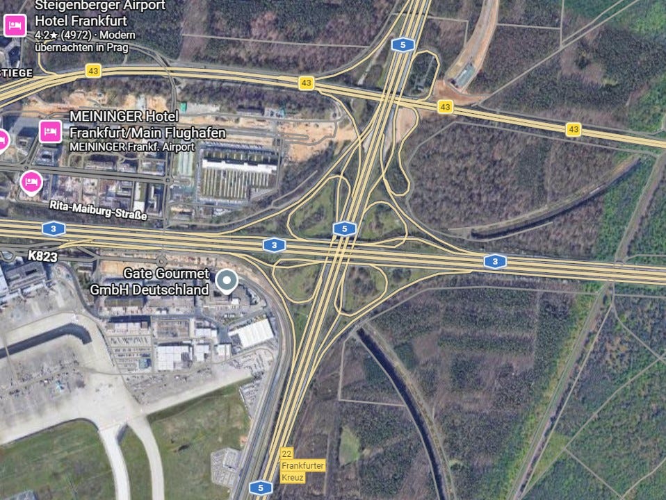
On roughly thirty-one hectares hemmed in by ten lanes of traffic on each arm, they recorded three hundred and nineteen species of ferns and flowering plants, more than twenty-two per cent of all the plant species then known in the whole city of Frankfurt, on about 0.12 per cent of its area. Nine of them were on the German and Hessian red lists of endangered species. Nothing is passing through the middle of that interchange. The species are there because they can stay. The interior is an island, an accidental nature reserve barely entered by anyone between management visits, and its value is entirely a value of place.
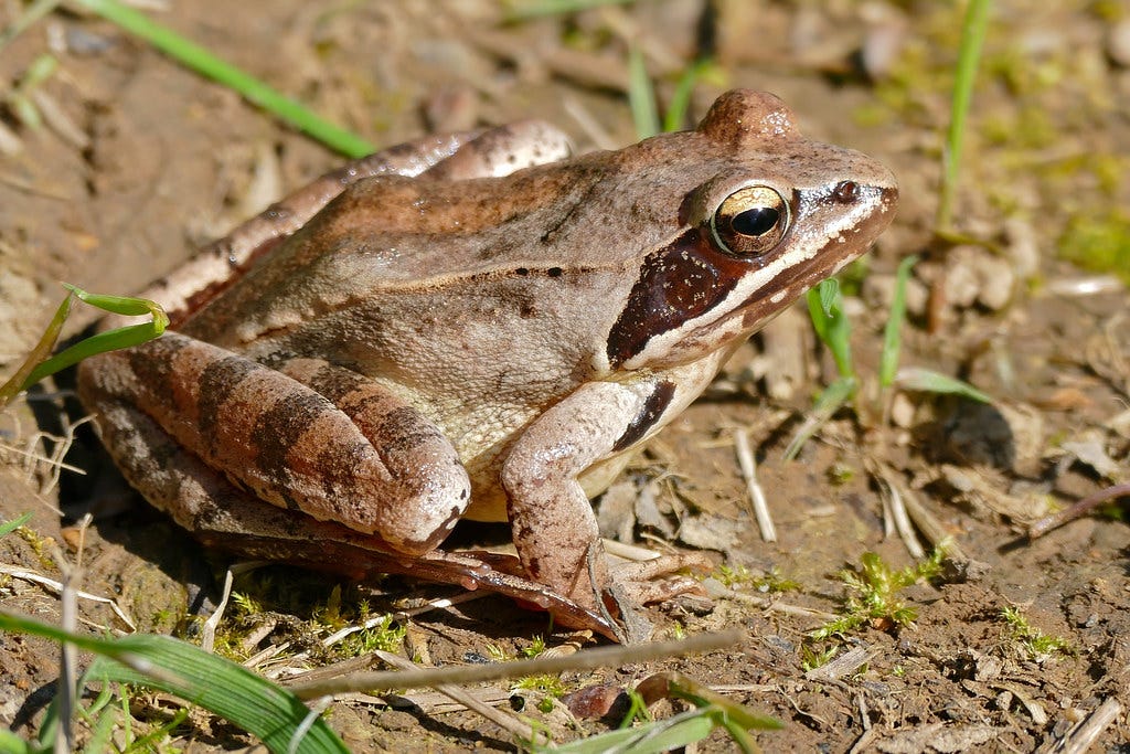
Once you start looking for place rather than passage, the transport estate fills with it. When Senckenberg carried out its survey of flora, fauna and biotope types around Frankfurt Airport, extending across the whole municipal forest south of the Main river, it found the Agile Frog, classed as highly endangered nationally within Germany, in unexpected strength. Previously recorded in the eastern city forest only in tiny numbers, it was counted in the springs of 2000 and 2001 with populations of more than one thousand five hundred spawning females. That is not a species using the forest as a route to somewhere better. It is a species living there, under the flight paths of one of Europe’s busiest airports, in woodland threaded by motorways and rail.
The pattern holds well beyond Frankfurt. In a 2019 paper in the Journal of Applied Ecology, one of the highest-impact journals in the field, Ben Phillips and colleagues showed that road verges and their hedges form an extensive network of semi-natural habitat that acts as a refuge for pollinators in farmed landscapes stripped of almost everything else, a point they developed in a companion 2020 paper on the services that verge network provides. A verge is a corridor and at the same time a place, a strip of grassland many species never leave. In a country that has lost ninety-seven per cent of its wildflower meadows since the 1930s, those ribbons may be among the most important habitat we have left, precisely because they escaped the ploughing and spraying that erased everything around them.
There is a framework sitting in plain sight that could fix this, and transport planners built it. For fifty years, British streets were designed as if their only purpose was to move vehicles from one place to another, the philosophy the 1963 Buchanan report captured in its image of roads as corridors between rooms. The Link and Place approach developed by Peter Jones and Stephen Marshall, set out in their 2007 guide, absorbed into the Department for Transport’s Manual for Streets and now woven through local transport strategies and the basis of much design guidance ever since, broke that habit. It insists that every street has two independent functions, a link function for movement through it and a place function as a destination in its own right, and that a street strong on one and weak on the other is only half designed. A high street is not a pipe. It is somewhere people stop.
Under the old paradigm the movement function came with full design standards, quantitative performance measures and an appraisal system that priced every minute of saved travel time. The place function came with partial standards, qualitative description and no comparable way to count its worth, so it was handed whatever space movement did not want. That is precisely how we treat nature. The movement half, from the plants briefly visited by pollinator to the huge wildlife bridges, gets engineered, specified and costed. The place half, the habitat, gets a paragraph in the environmental statement and whatever verge is left after the sightlines are drawn. Maybe the drainage ditch if its lucky.
Where my thinking has got to is this. We should classify and manage the land our infrastructure occupies on two axes for nature, exactly as Link and Place taught us to do for people. Every parcel, every verge, embankment, cutting, roundabout and interchange interior, carries a movement value for nature – its worth as a corridor that connects populations – and a place value – its worth as habitat where species live out their lives. The two are related but distinct and this produces a simple matrix with four broad types, each implying a different job.
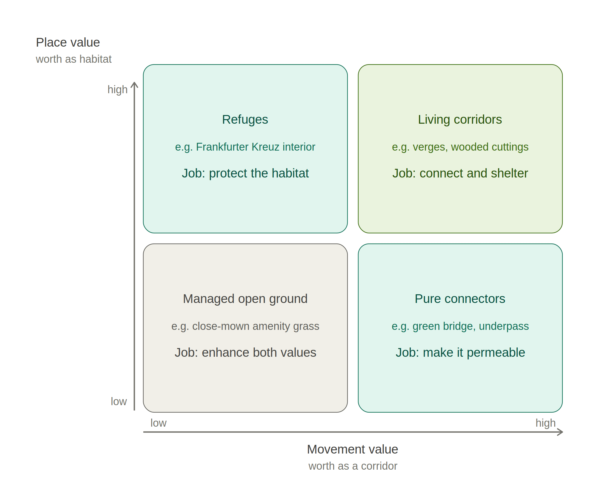
At one corner sit the pure connectors, high on movement and low on place, where a green bridge or a fauna underpass belongs and the design task is permeability, getting species safely across. At the opposite corner sit the refuges, high on place and low on movement, of which the interior of the Frankfurter Kreuz is the extreme case, an island going nowhere that happens to be a botanical hotspot. There the task is not connection but protection, shielding the habitat from disturbance and from the tidying instinct that reads long grass and scrub as neglect.
In another corner sit the parcels that score on both, a well-structured verge network or a wooded railway cutting that carries species along its length and shelters others that never leave. In the last corner sits open habitats with minimal coverage such as highly managed grasslands, with limited diversity of a few species, and next-to-no cover for the moving or sitting animal.
Naming the two values is what unlocks the rest, because you cannot design, measure or maintain for a function you have not acknowledged. There is a beginning here to build on. England’s biodiversity net gain rules, mandatory since February 2024, put a standardised number on habitat for the first time, scoring parcels by size, condition and distinctiveness with a multiplier for sites that serve a wider nature network. But that metric measures place for new development, not for the estate we already run, and it barely touches the corridor function. A movement and place framework for nature would extend the same logic to the transport infrastructure we already have, and give the movement value a measure of its own alongside it.
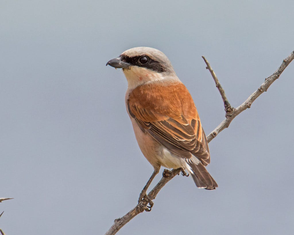
The teeth show at the level of routine maintenance. Managing the Frankfurter Kreuz as a high-place site would mean keeping its scrub deliberately open, because the Senckenberg surveyors found species such as the Red-Backed Shrike – a beautiful bird just bigger than a sparrow with a distinctive red back and even more distinctive call – breeding inside the interchange and warned that letting it grow over into dense bushland would erase the open ground the bird needs. Read that way, the mowing schedule is a conservation instrument.

A framework is only as good as the evidence feeding it, and this is where Frankfurt has quietly done the hard thing. Since 1985 the city’s environmental agency has commissioned Senckenberg to map the biotope types across the whole urban area, extending the survey into the municipal forest from the year 2000 and revisiting it on a roughly six-year cycle, an arrangement renewed in 2023 as a twelve-year research collaboration. Frankfurt has measured the biodiversity of its transport-threaded landscape continuously, for four decades, through a serious scientific institution. It also holds its forest inside a positive planning frame rather than a defensive one. The city treats the Stadtwald as core infrastructure, forming almost half of the GrünGürtel green belt and certified to Forest Stewardship Council standards since 2015, one of the systems rather than the obstacle the systems route around.
Put the evidence base and the infrastructure frame together and Frankfurt is pointing at something more significant than a well-run city forest. It has the building blocks in place for something genuinely radical, a transport landscape planned for the needs of nature as an equal priority to the needs of people. The institutional capability is the part almost nowhere else has. Four decades of continuous mapping is the thing that lets you say with authority which junction interior is a place worth keeping and which verge is a corridor carrying the last local population of something. Evidence of that quality can shape decisions rather than merely record the damage after it is done.
A framework is only worth building if it changes decisions, which means wiring it into operational policy, the design standards, maintenance specifications and appraisal weights that determine what actually gets built and cut. The failure mode is on display whenever we count only what is easy. When Frankfurt Airport built its fourth runway, the operator Fraport reports that 282 hectares of woodland were cleared and 288 hectares replanted, a tidy hectare-for-hectare balance that is movement thinking applied to place, treating a centuries-old forest as interchangeable with saplings on another plot. The place value, the part that cannot be replanted on a compliance schedule, does not enter the account because we have no settled way to make it.
We are, in truth, only at the start. Where authorities engage with nature at all they reach first for the easy wins: wildflower verges, cutting less and later, bee banks and swift bricks, none of which I would discourage. But in movement and place terms they are scattered gestures of place with no strategy behind them, and the scale of the problem has outgrown them. The State of Nature 2023 report compiled by more than sixty research and conservation bodies, found the abundance of the UK species it tracks down by around a fifth since 1970, one in six species at risk of being lost from Great Britain, and pollinator distributions down by 18 per cent. A country losing nature at that rate cannot treat its single largest networks – its roads, railways, canals and much more beside – as just a place for humans. It has to plan that network as a natural system in its own right, one of the largest habitat mosaics we hold that also happens to move people and goods.
What Frankfurt offers is not a template to be copied in its entirety, as its history makes it difficult to. Its forty years of Senckenberg mapping and its FSC-certified forest are the products of a particular civic culture, and few authorities will replicate them wholesale. But we can learn the lesson underneath. The land our infrastructure occupies is not dead ground and not merely a barrier to be bridged. It is a working mosaic of corridors and islands, movement and place. If the inside of the busiest highway interchange in Central Europe can be host to a haven for species, then most areas can be places for wildlife. Every transport body is already managing habitat, whether it means to or not.
The movement and place framework for people did not arrive fully formed, and that is the encouraging part. Someone had to build it. Jones and Marshall argued the place function into existence against fifty years of traffic-first orthodoxy, gave it a matrix and a set of indicators, and saw it written into the Manual for Streets and from there into the local transport strategies and design standards that now shape how a generation of planners think. Nature needs the same deliberate act. We need a movement and place framework for nature, developed with equal seriousness and embedded in the guidance and strategies that govern what we build and maintain, until classifying a verge or an interchange by its corridor value and its habitat value is as ordinary as classifying a street by its link and place status.
That is the shift I am arguing for. Its one I don’t think is particularly hard either – we just need people to do the initial intellectual work and framing to establish as a serious idea, and not just one from the mind of a single writer. We already know how to plan for two functions at once, because we learned to do it for streets when we stopped pretending they were only for traffic. Extending the same discipline to nature is not a scientific leap but a decision, and Frankfurt has built the evidence base that makes the decision defensible. The wildflowers on the verge are a start. Finishing the job means building the framework, and learning at last to see our roads and railways not as lines drawn across the landscape but as places within it.
It also challenges something more fundamental in ourselves. We often see the human world and the natural world as separate entities, partly built upon our own historical fears of what lurks in the dark recesses of the forest. Those fears were built from a time where there were monsters lurking in the dark. Today they have names, like bears and wolves. But that mindset has stuck, and is reinforced by how we try to manage transport networks as human infrastructure. Today we call that risk management, and seeing nature as a threat to safe and efficient operation of transport systems.
It’s time we thought different to that.
While I love writing this, and my writing will always remain free to view, if you are able to donate whatever little you can to help out it is much appreciated. I do have bills to pay after all! You can do that right here.
👩🎓 Further Reading
The clever clogs at our universities, government departments, and other clever people have published the following excellent research. Where you are unable to access the research, email the author – they may give you a copy of the research paper for free.
Do wildlife crossing structures mitigate the barrier effect of roads on animal movement?
TL:DR - A global synthesis that asks the awkward question about the thing we keep building. Of 313 studies reviewed, only 14 per cent actually tested whether a crossing changed animal movement across the road. The evidence suggests crossings can reduce the barrier effect, but many have been poorly implemented or evaluated. The takeaway is that we are spending millions on structures we rarely monitor.
Demographic effects of road mortality on mammalian populations —
TL:DR - A UK-led systematic review pulling together 83 studies covering 69 mammal species and 150 populations. The sobering finding is that raw roadkill numbers understate the damage, because road mortality can push death rates above reproduction rates and tip vulnerable populations toward local decline.
A global map of roadless areas and their conservation status
TL:DR - The paper that quantified fragmentation at planetary scale. About 80 per cent of Earth’s land is still roadless, but that space is shattered into roughly 600,000 patches, more than half of them under 1 square kilometre and only 7 per cent larger than 100 square kilometres.
Evaluating and elevating the role of wildlife road crossings in climate adaptation
TL:DR - A fresh argument that crossings are not only about safety and reconnection. Beyond reducing mortality and reconnecting habitat, they let species shift their ranges as the climate moves, which makes them a piece of climate-adaptation infrastructure we have been undervaluing.
Ecological Responses to Habitat Fragmentation Per Se
TL:DR - The most-cited challenge to corridor-and-big-block orthodoxy. Reviewing the studies that separate fragmentation from habitat loss, Fahrig found the effects of fragmentation itself were far more often positive than negative, and that a scatter of small patches can hold as much biodiversity as one large block.
😀 Positive News
World’s largest wildlife crossing gets an opening date
The Wallis Annenberg Wildlife Crossing over the 101 Freeway near Los Angeles will open on 2 December 2026, spanning ten lanes of freeway using twenty-six million pounds of concrete. The roughly ninety-two million dollar structure has been topped with living soil and will carry more than fifty native plant species, and butterflies and birds are already turning up on it before it even connects to the land.
India opens its first dedicated wildlife-overpass corridor
On the Delhi-Mumbai Expressway, through the Ranthambore Tiger Reserve buffer zone, the National Highways Authority of India built five wildlife overpasses of five hundred metres each plus the country’s longest wildlife underpass at 1.2 kilometres, planting 35,000 trees along the way.
National Highways doubles its green bridges in England
Three new wildlife bridges are under way, the A30 Marazanvose crossing in Cornwall, Cockrow Bridge over the M25 at Wisley installed in January 2025, and a crossing on the A417 near Gloucester, which together will double the number of green bridges in the UK within two years.
Scotland’s councils build pollinator networks into their verges
NatureScot’s Pollinator Strategy progress report describes councils setting up roadside verge and grassland schemes to create Nature Networks for pollinators, cutting and lifting at the end of the season while leaving twenty per cent uncut for winter cover.
💻 Hard Work
As I mentioned, this week I presented at Active County Cambridgeshire and at the Transport Practitioners Meeting. I cannot share the slides that I presented yet, but at Active County Cambridgeshire I presented some work that I have done on Forest City, and at Transport Practitioners Meeting I presented work I did with the Scottish Rural and Island Transport Community on ferries. You can see the report for the former here, and the report for the latter here.
In addition to this, the work on the Transport Box picked up the pace. We held two in-person workshops with a group of committed volunteer engineers, as my good friend Diana Powell showed how to run fun and interactive sessions with young people. The brilliant Ed Downer, Pauline Johnstone, and our work experience student Bethany Babrovskie helped make it all happen, despite - how to say - unexpected issues that were faced. And the heat was not one of them.


🎶 Musical Finale
I can’t help but hear the song Fake Plastic Trees by Radiohead and laugh. While the band wrote the song as a bit of a joke, the lyrics perfectly encapsulate our need to try and shape nature according to our tastes and whims.
🪧 Notices
This section is intended to notify you of important things that may or may not annoy you, depending on your view of the world. But these are things I feel it is worthwhile pointing out.
Regarding Artificial Intelligence. For my newsletter, I use AI like a research assistant. I get the AI (in my case Claude Opus 4.8) to find for me well-cited and evidenced research in the subject matter, focussed on academic journals with a high impact factor. I follow this up with my own research, and I check each source myself. Where I have the time to, I contact domain experts or seek out their published works to validate the findings. The words written here are my own, spelling mistakes and all.
Regarding my expertise. I am a transport planner, so my realm is public policy, how people and things move, and their impacts. While I research everything in a manner I consider robust, there may be some instances where my lack of domain expertise fails me. That’s on me, but that’s all part of learning. I always encourage any reader to do their own research on the subject matter.
✅ Sign Up
If you have been sent this newsletter, please consider signing up. Its free to do so, and I don’t spam your inbox with random rubbish - just my own words.